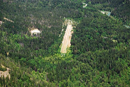
Stehekin Airport Runway.
Airport Alert
Important Runway Advisory:
Per NOTAM 6S9 06/189, the first 300 feet of Runway 13 are closed for both landings and takeoffs due to surface irregularities, including humps, rocks, and uneven ground. Pilots are advised to extend touchdown beyond the closed portion.
Recommended Operations: When conditions permit, it is recommended to land using Runway 31 to avoid the compromised section.
Special Operations Notice:
The airport is open earlier this season to support a National Park Service (NPS) contractor working on the Fire Cache Facility.
Please note:
• All aircraft operations are at the pilot’s own risk in accordance with WAC Chapter 468-250-130.
• Military flight training is prohibited in accordance with NPS policy.
• Law enforcement and fire operations should notify airport management prior to use.
Seasonal Access Reminder:
Recreational and business access in early spring may be limited or unavailable. Pilots should check with the National Park Service or local businesses before planning a trip.
Maintenance & Closure Information:
Additional spring and summer maintenance activities, as well as potential firefighting-related closures, may occur. Please monitor current NOTAMs for updates.
Contact the State-Managed Airports Coordinator John Wilson at john.wilson2@wsdot.wa.gov or 360-618-2477 for additional questions.
Location
ID
Sponsor
Weather information
Note: Forest Fire Fighting is common at this airport during summer months. Please check NOTAM's, TFR's and watch for helicopter activity. For additional information contact the State Airport Coordinator by emailing john.wilson2@wsdot.wa.gov or calling 360-618-2477.
Rules
 Camping
 Picnics
 No fire rings
 No outhouse
 No water
 Facilities
Available information for airport
Located just west of the village of Stehekin, at the head of Lake Chelan, Stehekin State Airport provides access to some of the most awesome scenery in Washington. This location is a favorite of campers, fishers, and hunters. Food, lodging, and resort activities are available in the village. Pack trips into the heart of the Cascades are also available. When you fly into this magnificent country you will be amazed by its beauty. However, the magnificence of the terrain makes Stehekin one of the most difficult airports in the state. It is definitely a strip for an experienced mountain pilot.
The 2,630 foot turf runway is rough, and frost heaved rocks are common, however our local maintenance man continues to improve the runway surface and keeps the irrigation system in service. Both approaches are difficult. There is a large mountain directly off the east end of the field. The runway slopes significantly uphill to the west, and tall trees surround the airport. There are tall trees at the east threshold of the runway, and are very close to the west end. The terrain rises rapidly and the valley narrows quickly to the west. Strong gusty winds are common. Though the field elevation is only 1,230 feet, density altitude problems are guaranteed in the summer. Lightweight aircraft with good short field characteristics can usually use the field any time of the day; others usually have to depart in the early morning. Animals are frequently present, with people and vehicles somewhat less common. It is essential to overfly the field to check conditions, and plan an approach strategy.
The most common approach method is to ignore wind direction, unless winds are strong, and land uphill to the west. With a good tailwind this results in difficulty getting down to the runway after passing over the trees on the east threshold, and a guaranteed long landing. Departures are usually to the east to take advantage of descending terrain, with aircraft gently moving towards the center of the valley after passing treetop height. We strongly recommend early morning arrivals and departures when the wind is calm and the temperatures are cool. The airport is usually open from June 1 to October 1 however if early or late season weather conditions allow, the airport will be open. Please check NOTAM’s for extended open periods.
All information subject to use disclaimer.