Fish passage maps & data
Find fish passage maps, get GIS data, and view our annual reports.
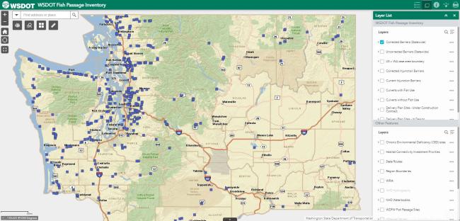
Find fish passage projects on a webmap
Tips for using our interactive map:
- Use the layers to view which sites have been corrected and which sites remain total or partial barriers.
- Click on the map to learn which species of fish are present at a particular site and view more photos.
- Turn different layers on and off to know where different boundaries are located.
- Use the measure tool to understand how close or far apart sites are.
- Turn the "Delivery Plan" layers on to view projects recently completed or programmed for completion over the next few years.
Public data download resources
- WSDOT Geospatial Open Data Portal – Find interactive maps, printable maps, and GIS data downloads.
- WSDOT Geospatial Open Data Portal - Fish Passage - Find fish passage datasets available in our Open Data Portal.
- WSDOT Online Map Center Data Gallery - Access map content including interactive map applications and GIS data layers.
- WSDOT Online Map Center Data Gallery- Fish Passage - Find fish passage map items available on our Online Map Center.
Our progress correcting barriers
As of June 2024, we have completed 146 injunction barrier corrections. These actions have improved access to approximately 571 miles of potential upstream habitat. We corrected 32 injunction barriers last year, improving access to 67 miles of potential upstream habitat.
Learn more about our progress identifying and correcting fish passage barriers, and related activities, in our 2024 WSDOT Fish Passage Performance Report (PDF 9.3MB).
View past annual reports here: WSDOT Annual Reports
Slow down on ice and snow.
It's easier to skid or lose control traveling at higher speeds. Give yourself more time to stop.
Carry chains, practice installing them.
Winter conditions could mean chains are required on your route. Practice putting them on your vehicle ahead of time.
Pack your winter car kit.
Carry extra supplies like warm clothing, ice scraper and brush, jumper cables and other emergency items.