In 2020, WSDOT received a Salmon Recovery Funding Board (SRFB) grant to characterize and assess existing riverine and floodplain conditions in the Skagit River, and explore a floodplain restoration alternative as a potential solution to reduce flood and erosion damage to State Route 20 and improve native fish habitat in the river and its floodplain.
The feasibility study and report were completed in December 2023, and the report is available for viewing and download below.
Timeline
January 2022 - December 2023
Status
Complete
Budget
$313,000
Purpose
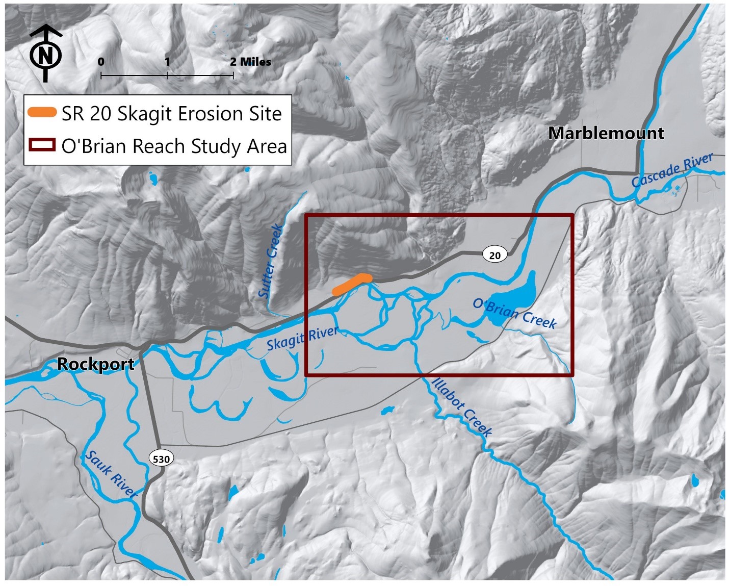
The SR 20 Skagit River O’Brian Reach Feasibility Study area is located along SR 20 near Rockport at milepost 101. This section of SR 20 experiences frequent embankment erosion and flooding and has required repeated emergency repairs following floods in the Skagit River. The purpose of the study was to characterize and assess floodplain connectivity, hydraulic processes, and fish habitat to determine if there is a feasible floodplain restoration action that:
Improves degraded fish habitat in the Skagit River and its floodplain by enhancing the connectivity of floodplain habitats to the river during small and medium-sized floods.
Reduces erosion and flood damage to SR 20 during frequent flood events and does not increase risk to adjacent property or infrastructure.
Is acceptable to the community and feasible based on other factors, such as cost, sustainability, wildlife, recreation, aesthetics, and opportunities to collaborate.
This technical study engaged potential project partners and the public throughout the study, and the results were documented in a feasibility study report. This was not a project planning study, and the alternatives evaluated will not result in a WSDOT project proposal.
Since the 1990’s, SR 20 near milepost 101 has experienced frequent embankment erosion and flooding and required repeated emergency repairs following floods in the Skagit River. This section of the highway is located below the 10-year flood elevation along a meander of the Skagit River that has been slowly migrating downstream.
WSDOT’s Chronic Environmental Deficiencies (CED) program was exploring solutions to address the flooding problem and sponsored the feasibility study. The purpose of the CED Program is to protect state highways from flooding and erosion at frequent repair sites by constructing climate-resilient, nature-based, fish-friendly projects. These projects aim to work with watershed processes that often occur on a large scale.
A large portion of the floodplain of the O’Brian Reach is undeveloped, dedicated to conservation use, and managed by organizations working toward salmon recovery in the basin. This presented an opportunity to collaborate with potential conservation partners on a large-scale approach that addresses both problems, instead of implementing a site-specific, bank protection structure adjacent to the highway.
The study results showed that one of the two evaluated restoration alternatives had a potential significant increase in fish habitat quantity and quality but showed only minimal reductions in flood or erosion risk to SR 20. Although the results indicate a floodplain restoration project would not significantly improve flood conditions at the highway, the study effort gathered valuable information on hydraulic processes and habitat in the reach that could inform future restoration and flood protection efforts by others.
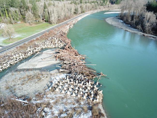
The Skagit River has migrated towards SR 20 near milepost 101, causing erosion and the need for frequent bank protection projects. Large rock protects the upstream (upper part of photo) portion of the embankment. The downstream embankment (lower part of photo) is protected by the Skagit dolotimber project – a successful, fish-friendly bank protection project installed in 2015, consisting of large concrete jacks and large wood. Photo credit: Natural Systems Design, December 2021.
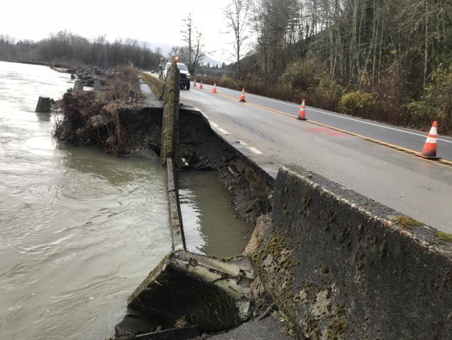
In November 2017, a small flood event in the Skagit River scoured and eroded the SR 20 embankment at milepost 101, resulting in a 2-week highway closure to repair the highway.
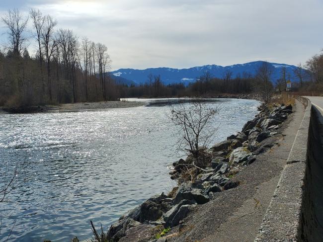
Large rock along the SR 20 embankment contributes to degradation of fish habitat in the Skagit River. March 2021.
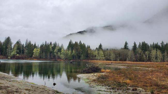
Floodplain habitat in the O'Brian reach across the river from SR 20 that could be potentially enhanced. This property is already in conservation use. December 2019.
Floodplain habitat in the O'Brian reach across the river from SR 20 that could potentially be enhanced. This property is already in conservation use. December 2019.
January 2022
Study planning, initial stakeholder outreach, data collection.
July 2022
Develop and refine the hydraulic model, study and document existing conditions, Public Workshop #1, refine evaluation criteria.
January 2023
Develop and evaluate alternatives, compare alternatives to existing conditions, review and revise model results, Public Meeting #2.
July 2023
Refine the analysis, select a feasible project concept to present in the report, prepare the report.
December 2023
Publish the final Skagit O’Brian Reach Feasibility Study Report.
The SR 20 Skagit O’Brian Reach Feasibility study was sponsored through WSDOT’s Chronic Environmental Deficiencies (CED) Program and funded with a salmon recovery grant and contributions from partners in the following amounts:
WSDOT does not intend to pursue funding for the design or construction of a project.
The SR 20 Skagit CED O’Brian Reach study characterized the hydraulic conditions and fish habitat in the floodplain, identified the river processes contributing to erosion and flooding of SR 20, and determined if a feasible project concept could reduce flooding of the highway and improve fish habitat in this section of the river. The results indicate that although both alternatives had potential significant increases in fish habitat quantity and quality, they showed only minimal reductions in flood or erosion risk to SR 20.