Needs and benefits
The purpose of the project is to develop a cost-effective, long-term solution that improves congestion, increases safety, and accommodates growth.
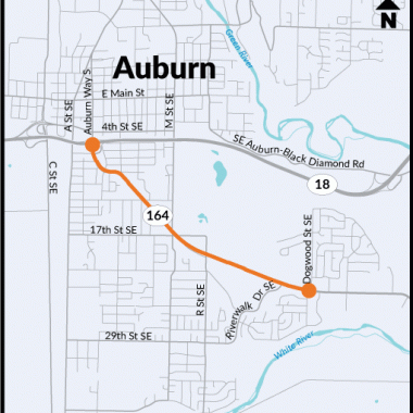
- Improves congestion: Reduces travel time, decreases queuing that blocks driveways and intersections, and improves reliability for emergency response for the section of SR 164 between SR 18 in Auburn and Dogwood Street Southeast on the Muckleshoot Indian Reservation. This segment has recurring congestion and traffic backups that extend through intersections. It will also help move people and goods more smoothly through the corridor.
- Improves safety: Reducing congestion reduces the potential for collisions. The project will also look at options to improve safety for cars, trucks, buses, bikes and people of all abilities.
- Accommodates growth: Allows for current and future land use in the urban growth areas of King County, Auburn, Enumclaw, and the Muckleshoot Indian Reservation.
Project concepts
There are four project concepts under consideration:
Concept 1: Improve current corridor
- Improvements to SR 164/Auburn Way South corridor including turn-lanes and channelization at congested locations.
- Potential grade-separated lanes at the SR 18 interchange.
Benefits of this concept include:
- Uses the current roadway within the right of way.
- Low environmental impact.
Challenges of this concept include:
- Right-of-way and access may be impacted for existing businesses.
Concept 2: New local connection
- Extend R Street south of Auburn Black Diamond Road under SR 18 to 17th Street Southeast
- Potential extensions from R Street to M Street using 6th Street Southeast, and 12th Street Southeast
Benefits of this concept include:
- Provides new north-south regional connection and access to developable land within the urban growth area.
- Uses existing R Street undercrossing.
- Consistent with city plans.
Challenges of this concept include:
- May increase traffic across BNSF tracks.
- Right-of-way is constrained at north intersection.
- Connects indirectly to SR 164/Auburn Way South.
Concept 3: Enhance access to SR 18
- Connection between SR 164/Auburn Way South and SR 18 with either new ramps to SR 18 or connecting to existing ramps at Auburn-Black Diamond Road.
- New roadway connection between SR 18 or Auburn-Black Diamond Road and SR 164/Auburn Way South somewhere between Muckleshoot Plaza and Dogwood Street Southeast.
- Includes new connection between Auburn-Black Diamond Road and M Street Southeast.
Benefits of this concept include:
- Provides direct arterial access to SR 18, bypassing SR 164/Auburn Way South.
- Could use the existing SR 18 ramps at Auburn-Black Diamond Road.
- Could improve or eliminate at-grade, skewed BNSF crossing or allow bypass of the crossing using M Street.
Challenges of this concept include:
- New SR 18 access ramps would be costly and may affect traffic on SR 18.
- New roadway connection at Dogwood would require mitigation of neighborhood impacts.
- Connection at Muckleshoot Plaza and Riverwalk could impact tribal property.
- Connection at Riverwalk could affect casino buildings and circulation.
Concept 4: Eastern connections to Auburn-Black Diamond Road to Auburn Way South
- Connections from SR 18 at the Auburn Black Diamond Road interchange to SR 164/Auburn Way South.
- Potential optional connections at Academy Drive Southeast or Noble Court Southeast.
- Uses existing right of way on Green Valley Road.
Benefits of this concept include:
- Provides new north-south connection and access east of Auburn.
- Provides a direct regional connection between SR 18 and SR 164/Auburn Way South.
Challenges of this concept include:
- Outside Urban Growth Area.
- Not identified in comprehensive plans.
- Traverses steep and unstable slopes.
- Could increase traffic adjacent to schools.
- Impacts to heritage sites and farmland.
Evaluation criteria
As we evaluate these concepts, we will consider transportation benefits and effects to the built and natural environment. Each will be evaluated as part of the Practical Solutions process. These resource areas are those identified in the National Environmental Policy Act (NEPA) and must be evaluated as part of the project.
This project received $15 million from the 2015 Connecting Washington transportation package.
There are currently no maps or drawings related to this project.
This Flickr album shows maps of the four project concepts under consideration.

