Project overview
The project will increase safety for the public on the US 2 corridor by addressing four slopes with a history of active rockfall. The project will reduce the risk of rockfall by repairing damaged slope stabilization systems at three rock slopes and by scaling loose rock at the remaining rock slope, all located in the Tumwater and Stevens Pass area. By not completing this project, the traveling public might run the risk of suffering property damage as well as injury and delays posed by rocks falling onto the roadway.
What to expect
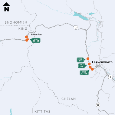
There will be four work sites. Site 1 will be from milepost 60-61. Site 2 will be on milepost 94. Site 3 will be on milepost 96 and Site 4 will be from milepost 97 to 98.
On Site 1, travelers may expect a single, right-lane closure on the four-lane section near Big Windy. This work may occur at the same time as sites 2-4.
On the three project sites in Tumwater Canyon (sites 2-4), work will occur sequentially, with all work completed on a slope before proceeding to the next.
On Site 2, travelers may expect a single-lane closure with flagging. There will be 20-minute holds on days with scaling.
On Sites 3 and 4, travelers will encounter a single-lane closure with flagging. On days where scaling will occur there will be a full closure estimated to last about two days. During this time, we will detour traffic on Chumstick Highway, and freight on Blewett Pass.
This map shows the extent of the work, from the Stevens Pass areas, heading east to Coles Corner and then southeast to Leavenworth.

