Multimodal mobility dashboard - Tri-Cities region
Region executive summary
This dashboard provides detailed multimodal mobility analyses of two urban highway corridors in the Tri-Cities region, which includes
- US 395 between Interstate 82 and I-182
- State Route 240 between Stevens Drive/Jadwin Avenue and I-182
The peak periods for both corridors in the Tri-Cities region are 6-8 a.m. and 3-6 p.m.
2023 Highlights
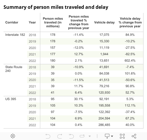
- In 2023, the average daily person miles traveled increased by 3.4% from 2022 and surpassed pre-pandemic levels. Approximately 337 million person miles were traveled on the SR 240, I-182 and US 395 corridors in the Tri-Cities region in 2023, up from 326 million person miles in 2022.
- Vehicle delay on the SR 240, I-182 and US 395 corridors in the region increased 1.9% from 421,066 hours in 2022 to 428,961 hours in 2023

US 395 and SR 240
US 395 and SR 240 in the Tri-Cities region are key commute and economic corridors. WSDOT classifies both as T-1 freight corridors, meaning that trucks carry over 10 million tons of freight on each corridor annually. US 395 between I-82 and I-182 includes a five-mile section in Kennewick with eight traffic signals as well as two smaller freeway segments. SR 240 between Stevens Drive/Jadwin Avenue and I-182 (known as the Bypass Highway) has traffic signals along its full length. Click the green bar below for additional on US 395 and SR 240 multimodal mobility analysis.

Multi-year trends
General purpose lane person miles traveled and vehicle delay:
- Annual GP person miles traveled increased 2.9% from 105.2 million miles in 2019 to 108.3 million miles in 2023
- Annual GP vehicle delay was up 49.0% from 196,000 hours in 2019 to 292,000 hours in 2023
Commute times:
- Commute times for peak morning and evening commutes continued to increase and some routes exceeded pre-pandemic levels
- The nine-mile morning commute from US 395 Kennewick to Pasco (northbound) in the GP lanes took an average of 12 minutes in both 2019 and 2023
Delay:
- Annual average daily vehicle hours of delay on southbound US 395 at Yelm Street increased 64.2% from 150.8 hours in 2019 to 247.6 hours in 2023
Severe congestion:
- Severe congestion had mixed results in 2023, some commutes were at or surpassed pre-pandemic levels. For example, at 5:20 p.m. speeds on US 395 from Pasco to Kennewick were below 36 mph on 41.5% of weekdays in 2023 up from 23.9% in 2019.