Fish passage - Projects & progress
Performance analysis
2023
WSDOT a catalyst for downstream barrier removal on State Route 20
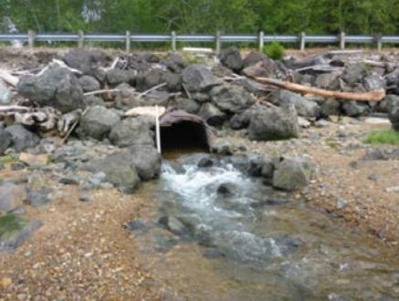
In August 2023, WSDOT corrected a barrier under State Route 20 at milepost 94.47 on Thompson Creek, a tributary to Middle Fork Skagit River, which flows under SR 20 between the towns of Concrete and Rockport in Skagit County.
WSDOT coordinated with a private landowner to correct a private barrier downstream of the SR 20 Thompson Creek fish passage project. The landowner constructed a new bottomless culvert which allows the landowners to continue using existing ATV trails. This private fish barrier correction was coordinated by the Skagit Fisheries Enhancement Group and funded by Puget Sound Energy & U.S. Fish and Wildlife Service Partners Program.
The previous undersized culvert was not only a fish passage barrier, but also caused many issues related to water quality. When Thompson Creek flowed over into the road and adjacent forest, it caused unnatural erosion and distribution of gravel road fill, which can degrade water quality for fish.
Correcting the private barrier and the SR 20 culvert restored access to 0.75 miles of high quality, forested spawning and rearing habitat upstream for steelhead, coastal and resident trout.


WSDOT works with Elwha Tribe for improved aquatic and terrestrial passage on Indian Creek
The recently completed Indian Creek fish barrier removal project on US Highway 101 resulted in a wildlife underpass large enough to safely accommodate all species of animals on the Olympic Peninsula, including elk. Within weeks of completion, a mink was recorded using the underpass and the first month of camera monitoring revealed several black-tailed deer herds crossing as well. Two years of pre-construction monitoring documented no native species crossing beneath US 101 using the old structure.
The culvert was replaced with a new 172-foot concrete girder bridge for enhanced fish migration. This project improved nearly 10 miles in potential habitat gain for migratory species. The Elwha Tribe has performed numerous restoration efforts on the creek and continues to work with WSDOT to enhance the channel by placing additional large woody material.


Monitoring ensures barrier corrections are functional and fish passable
The recently completed Indian Creek fish barrier removal project on US Highway 101 resulted in a wildlife underpass large enough to safely accommodate all species of animals on the Olympic Peninsula, including elk. Within weeks of completion, a mink was recorded using the underpass and the first month of camera monitoring revealed several black-tailed deer herds crossing as well. Two years of pre-construction monitoring documented no native species crossing beneath US 101 using the old structure.
The culvert was replaced with a new 172-foot concrete girder bridge for enhanced fish migration. This project improved nearly 10 miles in potential habitat gain for migratory species. The Elwha Tribe has performed numerous restoration efforts on the creek and continues to work with WSDOT to enhance the channel by placing additional large woody material.
Monitoring Summary
The 2023 monitoring effort reflects all statewide activities during 2023, including injunction relevant and non-injunction locations. WSDOT conducted 97 monitoring assessments, including:
- 32 Post-Construction Compliance Inspections,
- 14 Over-Winter Assessments,
- 22 Year 5 Evaluations, and
- 12 Year 10 Evaluations
Plus:
- 12 Additional Monitoring Evaluations at 11 sites,
- 2 assessments for repairs and/or modification, and
- 3 assessments under condition of WSDOT's Fish Passage Design Build Warranty
Of the 32 Post-Construction Compliance Inspections, all were within acceptable monitoring parameters, except SR 96 North Creek. This location experienced a 100-year event immediately following construction that disrupted conditions in the culvert, dislodged mobile wood from inside the culvert and deposited it onto the large woody material downstream. It was subsequently flagged for increased monitoring.
WSDOT updates Fish Passage project delivery plans quarterly or more frequently based on new information.
2022
WSDOT and King County partner to remove three fish barriers at Ravensdale Creek, SR 169
Located just south of Maple Valley, the SR 169 Ravensdale Fish Passage project removed three culverts that blocked fish migration, built two new bridges and improved fish and wildlife habitat. The former fish barrier was immediately upstream of two King County barriers.
WSDOT worked with King County to identify opportunities to fix these barriers and partner on a larger project to restore the creek. King County received funding through the Brian Abbott Fish Barrier Removal Board, which allowed it to collaborate with WSDOT on designing and constructing a new stream channel that entirely removed an access road and constructed a new pedestrian bridge for the trail. WSDOT completed the project's design, permitting and King County reimbursed WSDOT for the costs specific to work related to county crossings.
Bundling these three corrections into a single design and construction effort not only minimized the effects of construction on the stream and adjacent high-quality habitats, but also reduced the impacts on people who travel SR 169 or use the Black Diamond Open Area's extensive trail system.
This project opened access to over two miles of salmon and steelhead habitat and benefited recreational users in the park by providing safer access. View WSDOT's YouTube video showing Ravensdale Creek (before and after) improvements here: https://youtu.be/9EbG541uEhU.


WSDOT partners with City of Bellingham to improve fish and terrestrial habitat connectivity
Padden Creek, originating in nearby Lake Padden Park, crosses I-5 and flows through the City of Bellingham in Whatcom County before flowing into Bellingham Bay. Protected lands known as the "Chuckanut Wildlife Corridor" provide high-quality habitat for native wildlife species but the proximity to I-5 also resulted in high rates of deer-vehicle collisions in this area. Taking this into account, the crossing was designed with terrestrial wildlife safety in mind and incorporated connectivity features—such as adequate structure size for deer passage and passable walking corridors adjacent to the stream for other animals.
WSDOT's strong partnership with the City of Bellingham has been instrumental in addressing the removal of additional downstream barriers throughout the watershed (refer to the graphic below).


Monitoring ensures barrier corrections are functional and fish passable
WSDOT conducted 48 monitoring assessments during 2022, including:
- 14 post-construction compliance inspections,
- 14 over-winter assessments,
- Five long-term evaluations relevant to the injunction,
- 10 sites had increased monitoring after observing stream responses outside of the expected norms,
- Two ad hoc assessments to re-evaluate project performance, and
- Three assessments for sites needing performance management.
Of the 14 post-construction inspections, all were within acceptable monitoring parameters. Of the 14 over-winter evaluations, WSDOT determined four projects needed additional monitoring. Of the five long-term evaluations conducted, all met fish passage standards and stream function for year-five interval reporting. For the 10 sites that received additional monitoring, five remain on an annual review schedule, three no longer pose a concern for fish passage—reverting to the regular monitoring schedule, and two were proposed for performance management. Monitoring is a vital component of WSDOT's Fish Passage Program that informs the agency to make data-driven decisions regarding designing and maintaining fish passable structures (refer to the 2023 WSDOT Fish Passage Annual Performance Report for full details on WSDOT's monitoring effort). Individual monitoring reports can be generated on the WSDOT Fish Passage Inventory web map by entering a site's unique Site ID or clicking on a corrected barrier.
Fish passage program delivery progress
WSDOT continues work to comply with the requirements of a U.S. District Court injunction to correct barriers to salmon and steelhead, and open 90% of cumulative blocked habitat for all barriers within the injunction area having 200 or more yards of upstream fish habitat by 2030. WSDOT has significantly increased the number of projects that are under construction contract and beginning design in the 2023-2025 biennium.
Additionally, two barriers outside of the injunction area are being corrected during summer 2023 with grant funding from the Brian Abbott Fish Barrier Removal Board, including sites at US97 crossing Johnson Creek, and a tributary to the Okanogan River north of Omak.
WSDOT updates Fish Passage project delivery plans quarterly or sooner based on new information.
For more information about WSDOT's fish passage program, visit Fish passage | WSDOT (wa.gov).
2021
WSDOT corrects the last barriers on Swauk Creek and restores nearly seven miles of potential upstream habitat
Swauk Creek crosses US 97 nine times along the highway corridor between Blewett Pass and Swauk Prairie, eventually discharging into the Yakima River. This project completes a multi-year restoration of Swauk Creek between two WSDOT barriers on US 97, locally known as the Mill Crossing at milepost 159.24 and the Boundary Crossing at milepost 159.66. This project corrected the last WSDOT fish passage barriers on Swauk Creek.
WSDOT and the Washington Department of Fish & Wildlife identified this barrier as a high priority for environmental retrofit due to the quality and length of potential habitat gain (6.92 miles) in this virtually-untouched section of mountain stream. The innovative design reused native bed materials, minimized grading to protect native vegetation, and preserved off-channel cold water refuge habitat.
Siebert Creek project restores 34 miles of potential upstream habitat
Siebert Creek is a large tributary to the Strait of Juan de Fuca that crosses US 101 at MP 256.1 between Sequim and Port Angeles. This project corrects the lowest fish passage barrier on Siebert Creek, restoring access to 34 miles of spawning and rearing habitat upstream for Chinook and coho salmon, steelhead, coastal and resident cutthroat trout and bull trout.
The new crossing is a full span bridge with reinforced walls to stabilize the bank slopes, as this area is geologically prone to landslides. The span between the walls is 50 feet wide. Adult Chinook salmon were observed within the project area and upstream of the new bridge during the post-construction monitoring inspection, which is the first documented observation of Chinook utilizing Siebert Creek.
2020
Fish passage monitoring ensures barrier corrections are functional and fish passable
In 2020, WSDOT inspected 51 individual sites—in accordance with the WSDOT Monitoring Plan—to evaluate the performance of previously-completed fish passage projects. Of the 51 inspections, 35 were interval inspections, including 16 Post-Construction Compliance Inspections, seven Over-Winter Inspections, and 13 Long-Term Evaluations. WSDOT also conducted Increased Monitoring Evaluations at 16 sites in 2020.
Fish passage monitoring is part of a vital feedback loop that assists WSDOT in making data-driven decisions regarding designing and maintaining fish passable structures.
Hungry Harbor fish passage partnership
In 2020, a concrete box culvert was constructed on SR 401 for an unnamed tributary to the Columbia River at Hungry Harbor. This completed the third and final phase of a large-scale restoration effort known as the Columbia-Pacific Passage habitat restoration project, a partnership between WSDOT and the Columbia River Estuary Study Taskforce.
This multi-phased project involved restoration at three separate tributaries to the Columbia River along the Washington shoreline. The project at Hungry Harbor restored tidal processes, expanded and enhanced wetlands, and vastly improved juvenile and adult fish access for foraging, rearing, and spawning. Juvenile salmon were observed in the new habitat immediately after the project was completed. Funding sources included WSDOT, the Salmon Recovery Funding Board, Bonneville Power Association, Lower Columbia River Estuary Partnership, Lower Columbia Fish Recovery Board, and the US Fish and Wildlife Service.
Coffee Creek barrier correction
Coffee Creek is located in Mason County and crossed US 101. This project relocated Coffee Creek to avoid replacing the existing culvert under US 101 and the on/off ramps to Shelton-Matlock Road. This approach satisfies the injunction by avoiding the need for a highway crossing. This project benefits chum, coho, steelhead, and sea run cutthroat trout, improving access to 13.3 miles of habitat. Adult salmon were observed spawning in the new streambed within months of project completion.
2019
WSDOT coordinates barrier corrections with partners
WSDOT supports partnerships with other public agencies, cities, counties, public and private enhancement groups, and others who seek to help advance this work. WSDOT collaborated with the Salmon Recovery Funding Board and the FBRB to fund the Buford Creek project, which was completed in 2019.
Buford Creek is a tributary to the Grand Ronde River along the Washington/Oregon border. The culvert conveying Buford Creek under SR 129 was a barrier to fish—including federally threatened steelhead—impeding their passage upstream to potential spawning habitat. WSDOT collaborated with the Nez Perce Tribe, WDFW, the Asotin County Conservation District and the Snake River Salmon Recovery Board to correct the fish passage barrier. The project replaced a corrugated metal culvert with a bottomless steel arch, restoring the streambed using WDFW stream simulation guidelines. The project improves access to fish habitat within the Nez Perce historic lands and provides a passable corridor for wildlife living within the Buford Creek Canyon.
SR 129 remained open to traffic during construction due to the importance of the highway as a transportation corridor for remote communities in eastern Washington and Oregon. Restoration efforts were led by the Nez Perce Tribe, which developed the vegetation restoration plan and was responsible for seeding, replanting and maintenance.
Fish passage monitoring ensures barrier corrections are functional and fish passable
Between July 2018 and June 2019 (FY2020), WSDOT inspected 41 individual sites to monitor the performance of previously-completed fish passage projects. Of the 41 sites inspected, 37 of them remain 100% passable by fish. The other four sites are at risk of becoming fish passage barriers again due to conditions changing over time. WSDOT is actively planning corrective repairs to these four sites to maintain sustainable routes for fish traveling to their natural spawning habitat.
Fish passage monitoring is part of a vital feedback loop that assists WSDOT in making data-driven decisions regarding designing and maintaining fish passable structures.