Multimodal mobility dashboard - South Puget Sound region
Region executive summary
This dashboard provides a detailed multimodal mobility analysis of the Interstate 5 (I-5) corridor between Federal Way and Olympia in the south Puget Sound region. The peak periods for the I-5 corridor in this region are 5 - 10 a.m. and 2 - 8 p.m.
2023 Highlights
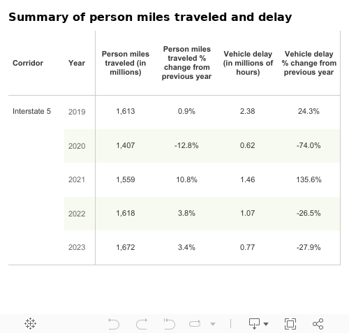
- In 2023, the average daily person miles traveled increased due to the continued recovery of traffic volume across the state in the wake of COVID-19. Approximately 1.67 million person miles were traveled on the I-5 corridor in the south Puget Sound region in 2023, up 3.4% from 1.62 million person miles in 2022.
- Vehicle delay decreased 27.9% from 1.07 million hours in 2022 to 0.77 million hours in 2023, due to construction being completed in the Tacoma area, which opened new northbound lanes and a southbound HOV lane on I-5
- In 2023, buses moved up to 3.7% of travelers compared to 2022, where buses moved up to 3.2% of travelers during weekday commutes
- Park and ride lots in this corridor had an average utilization rate of 37.3% in 2023 compared to 31.4% in 2022

Source: WSDOT Transportation Safety and Systems Analysis Division and WSDOT TRACFLOW (https://tracflow.wsdot.wa.gov/)
Interstate 5
Interstate 5 is the primary commute and economic corridor connecting the central and south Puget Sound regions. WSDOT classifies the I-5 corridor between Olympia and Federal Way as a T-1 freight corridor, meaning that trucks carry more than 10 million tons of freight on this corridor annually. This corridor is served by transit buses and by high occupancy vehicle lanes between Federal Way and Tacoma. It is also paralleled by the Amtrak Cascades passenger rail line. Click the green bar below for more information on Interstate 5 multimodal mobility analysis.

Multi-year trends
General purpose lane person miles traveled and vehicle delay:
- Annual GP person miles traveled increased 2.5% from 1.63 million in 2019 to 1.67 million in 2023
- Annual GP vehicle delay was down 70.6% from 2.38 million hours of vehicle delay in 2019 to 0.77 million hours in 2023
Commute times:
- The 28-mile morning commute from Olympia to Tacoma in the GP lanes took an average of 38 minutes in 2019 and 34 minutes in 2023
Delay:
- Annual average vehicle hours of delay on northbound I-5 near the Tacoma Dome decreased 100% in 2023 with no annual delay compared to 701.1 hours in 2019
Severe congestion:
- Severe congestion continued to increase in 2023, and surpassed pre-pandemic levels in some areas. For example, at 4:45 p.m. speeds on this commute from Tacoma to Lacey were below 36 mph, 60.0% of weekdays in 2023 up from 48.0% in 2019.
Throughput:
- Throughput productivity improved in 2023 for most monitored areas compared to 2019
Transit:
- Public transportation ridership has been experiencing a slow, steady recovery but remains well below pre-pandemic levels. In 2023, buses moved up to 3.7% of travelers compared to 2019, where buses moved up to 9.4% of travelers during weekday commutes in south Puget Sound highway corridors.
Park and rides:
- Park and ride lots in this corridor had an average utilization rate of 37.3% in 2023 compared to 81.4% in 2019