Wetlands - Projects & progress
On this page:
Performance analysis
2023
Advancements in technology streamline wetland monitoring
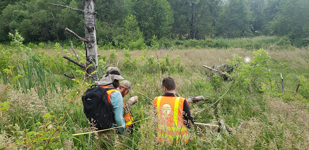
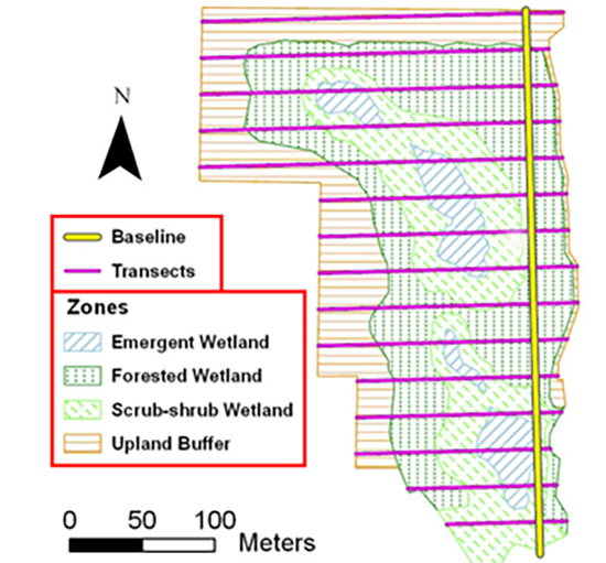
WSDOT streamlined fieldwork and vegetation monitoring using GIS technology to improve the efficiency of sample designs in the field. Sample designs are created to determine where and how WSDOT measures vegetation to meet the monitoring objectives at its mitigation sites. Two main components of the sample design are the baseline and transects. Once the baseline is established across the site, it serves as the starting point for all transects. Transects are placed randomly along the baseline and are used to collect data and measure plant communities. The length of the baseline and transects are recorded as important characteristics of the sample design.
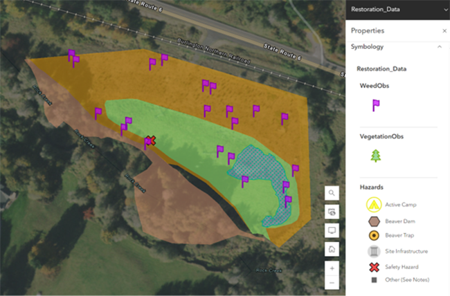
The transition to this technology has allowed for advanced field planning and preparation. Rather than creating sample designs in the field, WSDOT can now create them in GIS and upload them to the online service, where a map is made available for download to tablets. WSDOT employees can then navigate directly to the starting point of each transect, reducing the amount of time and personnel that it takes to manually create and set up a sample design in the field.


Converting to a GIS workflow also had significant advantages for data sharing between different WSDOT programs and regions. Using GIS, WSDOT can share the exact geographic location of noxious weeds, invasive species, and site hazards with site managers and restoration crews. In 2023, WSDOT collected approximately 30 location points for Class A, B, or C noxious weeds to be controlled and managed at wetland compensation sites. Ultimately, this transformative shift has improved efficiency, enhanced data quality, and resulted in clearer communication among various groups at WSDOT.

2022
WSDOT increases stipend for wetlands monitoring internship
WSDOT hired six interns in 2022. Summer interns help biologists monitor vegetation in the compensatory mitigation sites. WSDOT increased the stipend to the interns to reflect the evolving needs of the monitoring program.
WSDOT's internship training and plant laboratory returned to The Evergreen State College campus after going virtual in 2021 due to COVID-19. Interns receive college credit from TESC, while WSDOT provides a stipend to offset enrollment costs. The partnership between TESC and WSDOT has been in place for over 25 years. WSDOT's Wetlands ecology and monitoring techniques internship typically run from June to September.
The interns worked in concert with WSDOT's environmental drone program, which continued collecting images to support data collected by the interns for monitoring reports. They efficiently communicate compensatory mitigation site progression to the regulatory agencies.
2021
WSDOT restarts wetlands monitoring internship
WSDOT hired six interns in 2021 after pausing the Wetlands Ecology and Monitoring Techniques internship in 2020 due to COVID-19. Historically, WSDOT hired between 16-22 interns every summer to help biologists monitor vegetation at the mitigation sites. By reducing the number of interns, WSDOT was able to maintain safety protocols while completing the monitoring work.
WSDOT partnered with the Doris Duke Foundation to hire two of the six interns. The Doris Duke Conservation Scholars Program supports under—represented students in the fields of science by arranging applied internships. This process aligns with WSDOT's strategic goal of creating a more inclusive workforce. WSDOT's environmental drone program was able to continue collecting images for monitoring reports. These images support data collected by the interns. They efficiently communicate compensatory mitigation site progression to the regulatory agencies.
2020
COVID-19 pandemic affects wetland monitoring
In spring 2020, WSDOT halted field work—including wetland monitoring—due to the spread of COVID-19. This shortened the window for collecting wetland data. WSDOT typically hires between 16-22 interns every summer to help biologists monitor vegetation in the wetland compensation sites, but was not able to do so in the summer of 2020 due to the budget impacts of the COVID-19 pandemic. As a result, WSDOT biologists were unable to spend as much time at each site as they had in previous years.
Despite these obstacles, WSDOT found ways to comply with permit requirements. WSDOT and the regulatory agencies agreed on a plan to visit and report on each compensation site with reduced monitoring during the pandemic. WSDOT biologists prioritized the workload and relied more on technology. WSDOT's environmental drone program was able to safely continue conducting complementary monitoring for wetland compensation sites. Images collected using the drones were used in the monitoring reports to supplement reduced data.
2019
WSDOT programs support Practical Solutions and Workforce Development
Drone monitoring
WSDOT began using drones to conduct complementary monitoring for wetland compensation sites in 2019. Many wetlands formed dense native vegetation that grew vigorously within the 10-year monitoring period. Photos taken from the ground often show walls of vegetation and lack the appropriate perspective to show regulators or report reviewers the true development of the vegetation on the site.
Fifteen sites were selected for a pilot program that set permanent, repeatable photo points from the sky with drones. Oblique aerial photos—taken at a precise angle from designated points in the sky—give a perspective showing plant growth and vertical layering of plants for monitoring reports. This practical solution provides higher quality data with a fraction of the effort, uses low-cost technology, and is easy to repeat in future iterations.
Sustainability in Prisons Project
In 2019, WSDOT continued to partner with The Evergreen State College and the Washington State Department of Corrections to create and deliver environmentalworkshops to incarcerated individuals through the Sustainability in Prisons Project.
WSDOT provided training workshops to incarcerated individuals to highlight career opportunities related to wetland ecology and stormwater in support of workforce development. During these workshops, agency representatives highlighted how to navigate the state hiring process and gave tips on completing resumes and interviews.
Three workshops were held at Mission Creek Corrections Center for Women and three were held at Cedar Creek Corrections Center. These workshops support successful reentry to communities for formerly incarcerated individuals and cultivate a new pool of qualified workers for WSDOT's workforce.
