Multimodal mobility dashboard - Spokane region
Region executive summary
This dashboard provides a detailed multimodal mobility analysis of the Interstate 90 (I-90) in the Spokane area, which is one of the region's key commute and economic corridors. The peak periods for the I-90 corridor in the Spokane region are 7-10 a.m. and 3-6 p.m.
2023 Highlights
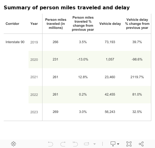
- In 2023, the average daily person miles traveled increased from 2022 due to the continued recovery of traffic volume across the state in the wake of COVID-19. Approximately 268.9 million person miles were traveled on the I-90 corridor in Spokane in 2023, up 3.0% from 261.1 million person miles in 2022
- Vehicle delay on the I-90 corridor in Spokane increased 33% from 42,000 hours in 2022 to 56,000 hours in 2023
- In 2023, buses moved up to 0.7% of travelers compared to 2022, where buses moved up to 1.6% travelers during weekday commutes in the Spokane region.
- Park and ride lots in this corridor had an average utilization rate of 9.4% in 2023 compared to 13.0% in 2022. None of these park and ride lots reached or exceeded a utilization rate of 85%, which is the threshold for being considered at full capacity.

Source: WSDOT Transportation Safety and Systems Analysis Division and WSDOT TRACFLOW (https://tracflow.wsdot.wa.gov/)
Interstate 90
Interstate 90 (I-90) in the Spokane area is one of the region's key commute and economic corridors. Almost 270 million person miles were traveled on I-90 between Division Street and Argonne Road in 2023. Select the green bar below for more Interstate 90 multimodal mobility analysis information.

Multi-year trends
General purpose lane person miles traveled and vehicle delay:
- Annual GP person miles traveled increased 1.2% from 265.7 million in 2019 to 268.9 million miles in 2023
- Annual GP vehicle delay was down 23.3% from 73,000 hours in 2019 to 56,000 hours in 2023
Commute times:
- The 7.5-mile evening commute from I-90 Argonne Road to Division Street (westbound) in the GP lanes took an average of nine minutes in 2019 and nine minutes in 2023
Delay:
- Annual avegage daily vehicle hours of delay decreased on westbound I-90 between milepost 284 and 284.5 decreased 64.6% in 2023 with 15.9 hours compared to 44.4 hours in 2019
Severe congestion:
- Severe congestion continued to increase in 2023, it was close to pre-pandemic levels. For example, at 4:45 p.m. speeds on this commute were below 36 mph, 52.7% of weekdays in 2023 similar to 53.1% of weekdays experienced at 5:20 p.m. in 2019.
Throughput:
- During the evening commute in 2023, throughput productivity decreased by two percetage points on I-90 at Freya Street eastbound where vehicle throughput was 77% compared to 79% in 2019
Transit:
- In 2023, buses moved up to 0.7% of travelers compared to 2019, where buses moved up to 3.7 travelers during weekday commutes in the Spokane region.
Park and rides:
- Park and ride lots in this corridor had an average utilization rate of 9.4% in 2023 compared to 82.0% in 2019.