Fish passage maps & data
Find fish passage maps, get GIS data, and view our annual reports.
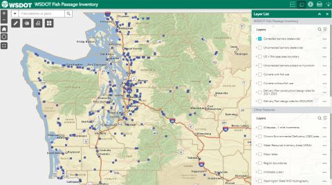
Find fish passage projects on a webmap
Tips for using our interactive map:
- Use the layers to view which sites have been corrected and which sites remain total or partial barriers.
- Click on the map to learn which species of fish are present at a particular site and view more photos.
- Turn different layers on and off to know where different boundaries are located.
- Use the measure tool to understand how close or far apart sites are.
- Turn the "Delivery Plan" layers on to view projects recently completed or programmed for completion over the next few years.
Public data download resources
- WSDOT Geospatial Open Data Portal – Find interactive maps, printable maps, and GIS data downloads.
- WSDOT Geospatial Open Data Portal - Fish Passage - Find fish passage datasets available in our Open Data Portal.
- WSDOT Online Map Center Data Gallery - Access map content including interactive map applications and GIS data layers.
- WSDOT Online Map Center Data Gallery- Fish Passage - Find fish passage map items available on our Online Map Center.
Our progress correcting barriers
As of June 2023, we have completed 114 injunction barrier corrections. These actions have improved access to approximately 502 miles of upstream habitat for fish. We corrected fourteen injunction barriers last year, opening 29 miles of stream habitat.
Learn more about our progress identifying and correcting fish passage barriers, and related activities, in our 2023 WSDOT Fish Passage Performance Report (PDF 11.7MB).
View past annual reports here: WSDOT Annual Reports
Slow down – lives are on the line.
In 2023, speeding continued to be a top reason for work zone crashes.
Even one life lost is too many.
Fatal work zone crashes doubled in 2023 - Washington had 10 fatal work zone crashes on state roads.
It's in EVERYONE’S best interest.
95% of people hurt in work zones are drivers, their passengers or passing pedestrians, not just our road crews.