How do you want to travel?

View data by road
See real-time alerts, cameras and restrictions in a list view by road.
Which road?
View alerts and cameras by route
View boarding status by terminal
Which airport?
Projects and improvements in your county.
Explore the progress of projects focused on creating safe and reliable ways to move people and goods around Washington.
County
Featured Project
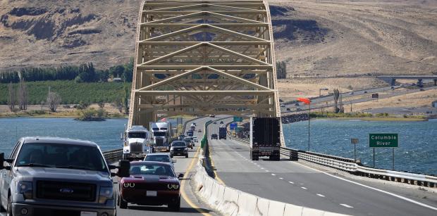
I-90 Vantage Bridge – Replace Bridge Deck and Special Repairs
Travelers crossing the Columbia River on I-90 will see lane closures over spring and summer as crews work to replace the entire surface of Vantage Bridge.
Access the resources you need to maintain and improve the transportation system.
Latest from WSDOT...
- Are you a high school student curious about how we decide where highways go, what we're doing to help the earth by reducing our carbon footprint or how we plan for the future of transportation while keeping people and goods moving? If so, we have a summer camp experience for you.
- Ashley Jackson has a message for drivers: Get off your phones while driving. Don't drink and drive. And, slow down and pay attention in work zones.
- FORKS – This summer, travelers will see one-way alternating traffic with temporary signals at six fish passage sites along US 101 in Jefferson and Clallam counties between Lake Crescent and Ruby Beach.